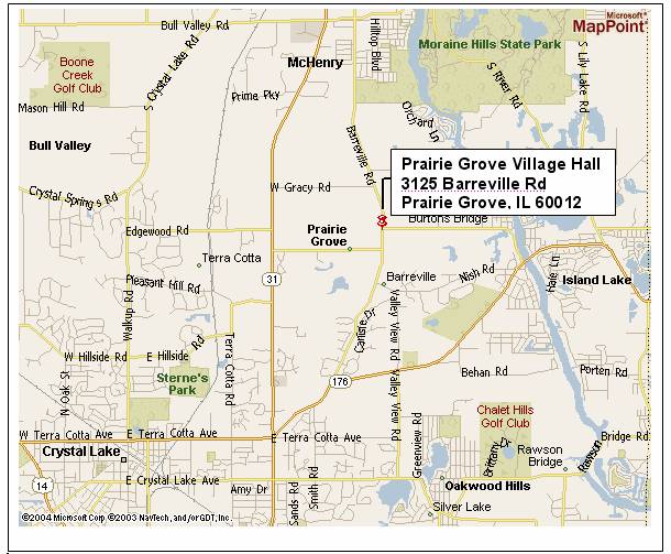
Where Are We?
We are a small village located in Southeast McHenry, IL county. The closest major intersection is Illinois State Route 31 (North/South) and Illinois State Route 176 (East/West). Neighboring communities include Crystal Lake to the West and South, Burton's Bridge and Island Lake to the East, Cary and Oakwood Hills to the Southeast and McHenry to the North.

Demographics
| Municipality | 2020 | 2010 | 2000 | 1990 | Change | Percent |
| Prairie Grove | 1963 | 1904 | 960 | 654 | 306 | 46.8% |
Males: 473 (49.3%), Females: 487 (50.7%)
Elevation: 760 feet
County: McHenry
Land area: 4.6 square miles
Zip code: 60012
Median resident age: 37.3 years
Median household income: $93,361 (year 2000)
Median house value: $285,800 (year 2000)
Races in Prairie Grove:
- White Non-Hispanic (96.1%)
- Hispanic (1.3%)
- Two or more races (0.7%)
- Black (0.6%)
(Total can be greater than 100% because Hispanics could be counted in other races)
Ancestries: German (33.8%), Irish (18.8%), Polish (12.6%), Italian (9.1%), English (8.2%), Swedish (7.0%).
For population 25 years and over in Prairie Grove village
- High school or higher: 91.0%
- Bachelor's degree or higher: 38.1%
- Graduate or professional degree: 11.8%
- Unemployed: 3.3%
- Mean travel time to work: 32.5 minutes
For population 15 years and over in Prairie Grove village
- Never married: 22.3%
- Now married: 64.6%
- Separated: 0.8%
- Widowed: 4.2%
- Divorced: 8.1%
4.1% Foreign born (2.4% Europe, 1.4% Latin America)
Type of Government
We are a Village Government with a Village President and Village Board of Trustees. On the March 16, 2004 election, the Village elected a Home Rule policy.
